NARRATIVE OF A SURVEY
OF THE
INTERTROPICAL AND WESTERN
COASTS OF AUSTRALIA.
PERFORMED BETWEEN
THE YEARS 1818 AND 1822.
BY
CAPTAIN PHILLIP P. KING, R.N., F.R.S., F.L.S.,
AND MEMBER OF THE ROYAL ASIATIC SOCIETY OF LONDON.
WITH
AN APPENDIX,
CONTAINING
VARIOUS SUBJECTS RELATING TO HYDROGRAPHY AND NATURAL HISTORY.
IN TWO VOLUMES,
ILLUSTRATED BY PLATES, CHARTS, AND WOOD-CUTS.
VOLUME 1.
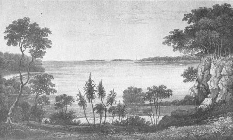
VIEW IN RAFFLES BAY, WITH CROKER'S ISLAND IN THE DISTANCE.
From a sketch by P.P. King.
Published in May 1825 by John Murray, London.
PREFACE.
THE rapidly-increasing importance to which the English Colonies in Australia have now arrived, rendering every subject connected with that extensive continent of the greatest interest, whether in respect to its geography, or the extraordinary assemblage of its animal and vegetable productions, has induced me to publish such parts of my Journal as may be useful to accompany the Atlas of the Charts of the Coast recently published by the Board of Admiralty.
One of the results of this voyage has been the occupation of Port Cockburn, between Melville and Bathurst Islands on the North Coast, and the formation of an establishment there which cannot fail to be productive of the greatest benefit to our mercantile communications with the Eastern Archipelago, as well as to increase the influence and power of the mother country in the South Pacific and Indian Oceans; and in contemplating this new extension of her possessions*, I cannot avoid recalling to mind a curious and prophetic remark of Burton, who, in alluding to the discoveries of the Spanish navigator Ferdinando de Quiros (Anno 1612), says: "I would know whether that hungry Spaniard's discovery of Terra Australis Incognita, or Magellanica, be as true as that of Mercurius Britannicus, or his of Utopia, or his of Lucinia. And yet, in likelihood, it may be so; for without all question, it being extended from the tropick of Capricorn to the circle Antarctick, and lying as it doth in the temperate zone, cannot chuse but yeeld in time some flourishing kingdoms to succeeding ages, as America did unto the Spaniards."** Burton's Anatomy of Melancholy, Part 2 Section 2 Number 3.
(*Footnote. The distance between Melville Island and Hobart Town in Van Diemen's Land, the former being the most northern, and the latter the most southern, establishment under the government of New South Wales, is more than 2700 miles, and comprises an extent of coast nearly equal to that of the British possessions in India!)
(**Footnote. Since the land that Quiros discovered and called Terra del Espiritu Santo was, at the time Burton wrote, considered to be the Eastern Coast of New Holland, I am justified in the use I have made of the above curious passage.)
Since the return of the Expedition, my time has been occupied in arranging the narrative, and divesting it of such parts as were neither calculated to amuse the general reader, nor to give information to the navigator; but this has been so much impeded by the more important employment of constructing the Charts of the Survey, as to defer until the present season the publication of the events of a voyage that