All About
The KLONDYKE
Gold Mines.
PUBLISHED BY
THE MINERS' NEWS PUBLISHING CO.,
60 Liberty Street, New York.
Copyrighted 1897
By THE MINERS' NEWS PUBLISHING CO.
LOCATION OF THE YUKON MINES.
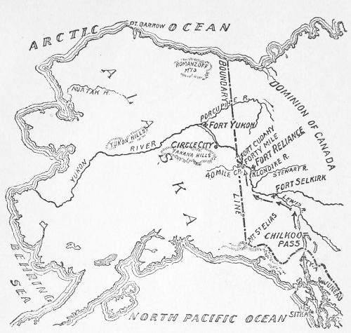
MAP OF THE YUKON GOLD DIGGINGS.
Sitka appears at the southeast corner of this map, and northeast of itis Juneau, the usual fitting out place for miners going to the Yukon.
The arrows show the route of miners bound for the Yukon. Steamboats cancarry them from Juneau as far as Ty-a. Then they must pack their loadsthrough Chilkoot Pass and boat them through a chain of lakes and downthe Lewis River to the Yukon. It is about 700 miles from Juneau to theKlondyke River.
The two other most important centres of Yukon mining were Forty MileCreek, where there were two big mining camps, Forty Mile and FortCudahy, and Circle City. All these camps have now been practicallydeserted in the great rush for the Klondyke.
The ever reliable and always trustworthy New York Sun publishes the mapas given above.
TABLE OF CONTENTS
| Map of the Location of the Yukon Mine | 5 |
| Gold—The Search for It, Past and Present | 9 |
| Klondyke and California—1849-1897 | 9 |
| The Geology of the Yukon | 10 |
| The "Mother Lode" and the Glacial Deposits | 10 |
| The Great Gold Discovery—How the First Authentic News Reached Us | 13 |
| The Gold Fever Spreading—The Stories of Some Miners | 14 |
| Millions of Gold Panned Out—Poor Yesterday—Rolling in Wealth To-day | 16 |
| Arrival of the Second Treasure Ship from the Klondyke | 19 |
| A Few of the Prizes Won | 21 |
| Some Grapes of Eschol Stories—Richer than Sinbad's Valley of Diamonds | 22 |
| The Stampede for the Gold—Thousands Join the Exodus | 24 |
| Where the Gold is Found—How It Is Reached and Mined | 26 |
| Some Large Nuggets—There Are More Where They Came From | 29 |
... BU KİTABI OKUMAK İÇİN ÜYE OLUN VEYA GİRİŞ YAPIN!Sitemize Üyelik ÜCRETSİZDİR! |